Itinerary Detail
Itinerary "B" - 8 days / 7 nights
Day 1 - Sunday
FLY TO GALAPAGOS & BOARD THE M/Y GALAPAGOS SPIRIT
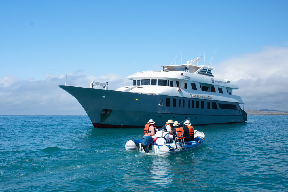
One of our Guides will take you to the Quito airport in time for your flight to Galapagos which is typically in the morning and arrives to Galapagos before noon. Transfer to the luxury yacht M/Y GALAPAGOS SPIRIT
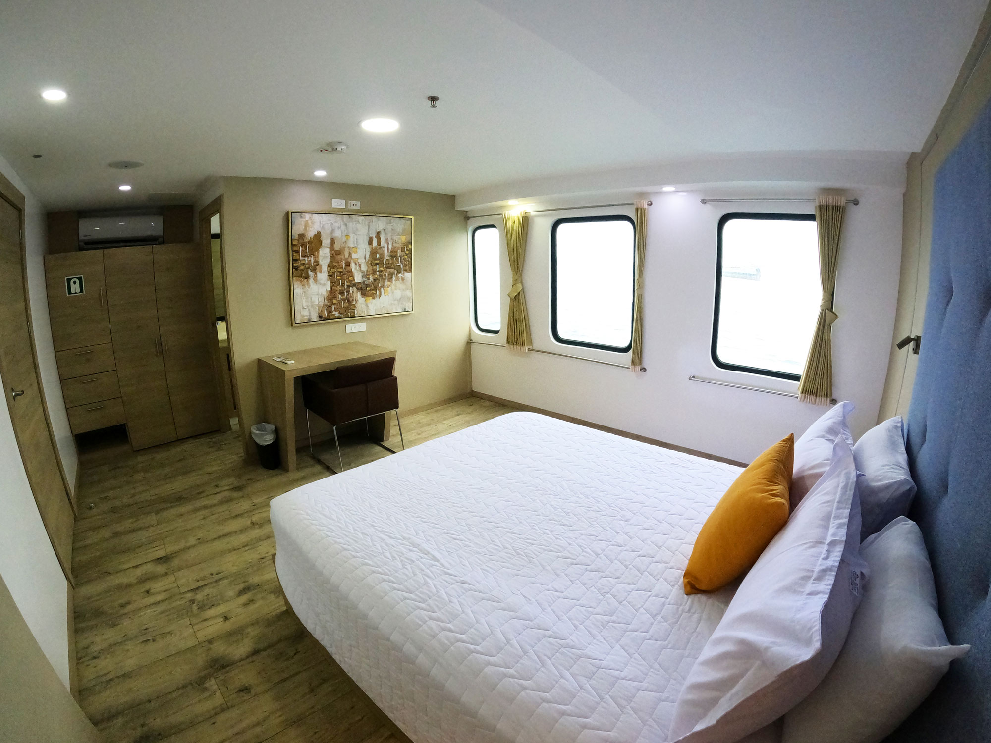
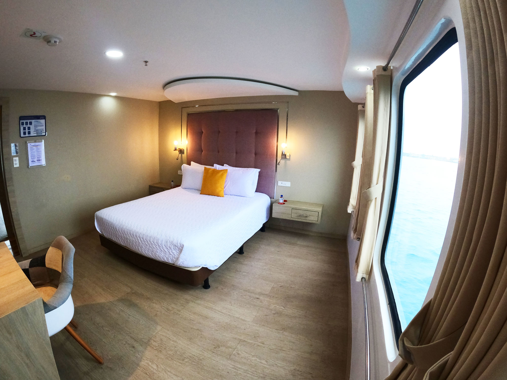
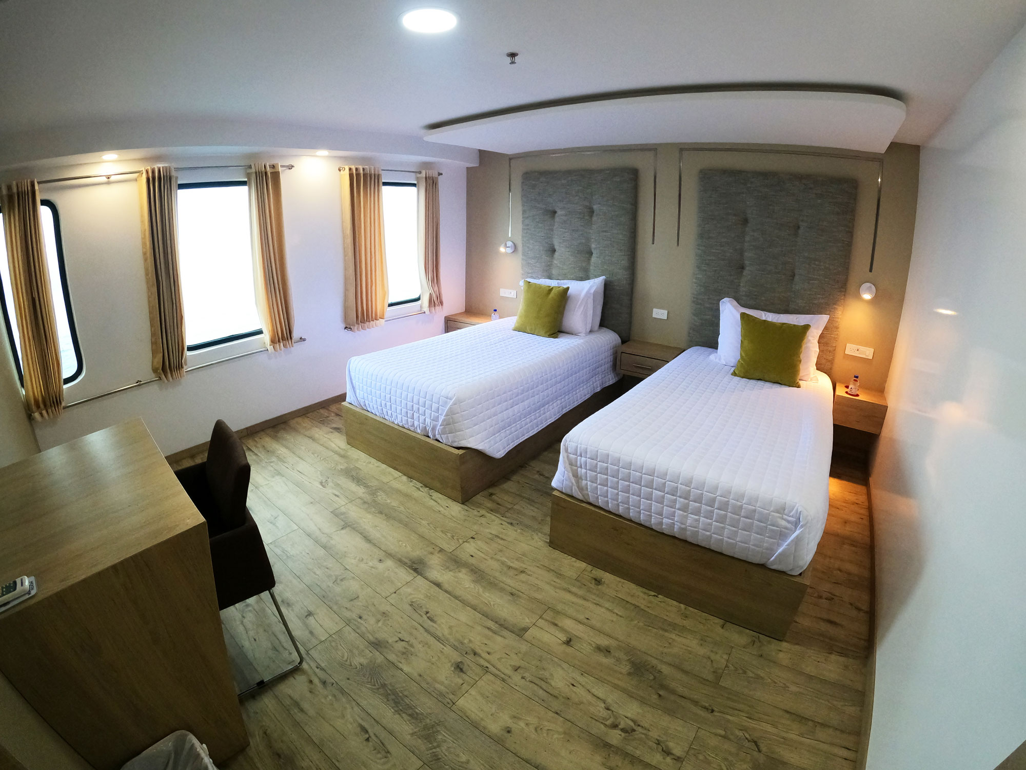
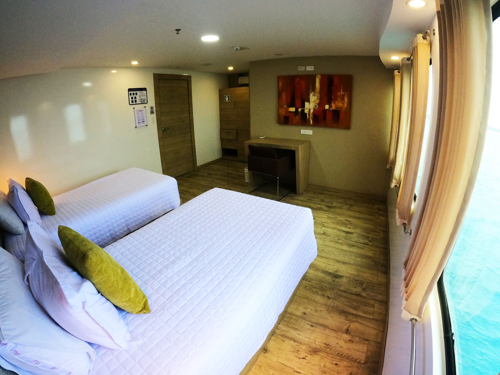
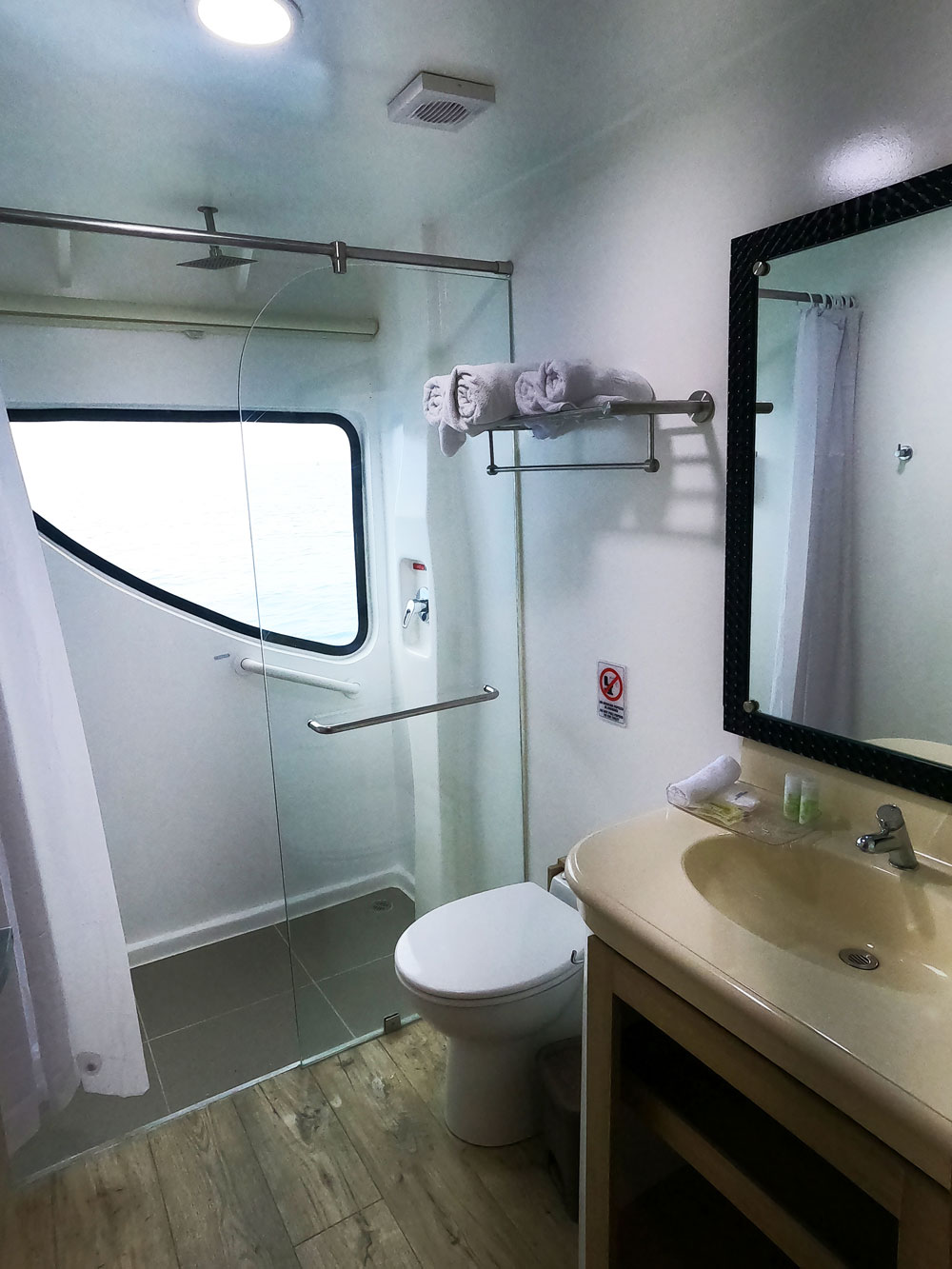
Begin your 7-night cruise through Darwin’s “Enchanted Islands”. Accommodation will be in eight cabins; 4 cabins on the main deck (2 queen size bed cabins and 2 twin bed cabins) and 4 cabins in the upper deck (2 queen size bed cabins and 2 twin bed cabins with private balcony). All cabins are spacious and feature a bath/shower and air-conditioning. All meals, snacks lectures and shore excursions are included.
The excursions and cultural programs are led by category “3” Naturalist Guide with years of experience in guiding in the Galapagos Islands and who stands out among the best Naturalist Guides in the whole archipelagos
PM: Interprettion Center & Tijeretas Hill
The Interpretation Center is an excellent place to learn about Natural History in the Galapagos and to learn about the San Cristobal History too. The Museum of Natural History displays information on the volcanic origins of the islands, their remoteness from the continent, ocean currents, climate, the arrival of the different species and their colonization, among other points of interest. Human history is also showcased, chronologically narrated by the most significant events related to the discovery and colonization of the islands.
Tijeretas Hill: It is called Tijeretas because this is the name commonly known for the frigates birds, it involves a high-intensity walk amidst beautiful landscapes and a magnificent view at the foot of a frigatebird nesting co (L, D)
Day 2 - Monday
AM: Bartolome Island
This is for sure the most iconic site of the Galapagos islands.
Bartolome is one of the most frequently visited sites of all the islands. The highest point is only 374 ft (114 m) above sea level, and it is separated from the island of Santiago by Sullivan Bay. It is an excellent site for snorkeling, filled with the breathtaking volcanic landscapes that make this corner of the world so unique.
The dock, made out of lava and concrete is our landing port, soon turns into a wooden staircase built to avoid erosion and consists of 372 steps. It takes us to the island’s summit, where we find what probably constitutes the most photographed site in the Galapagos: Pinnacle Rock.
Due to its altitude, the lack of vegetation is immediately noticeable. Pioneer plants are observed, they are called this way because they are the first to establish roots on new ground. They include Tiquilia nesiotica (which is endemic to the island) and Chamaesyce (known as sand mat or spurge in English), lava cactus, and Scalesia bushes. Behind the beach, we have the dunes covered by mangroves.
The coralline beach next to Pinnacle Rock is a wet landing site from which we are able to snorkel amongst tropical fish and perhaps sea lions and penguins; they rest on the lava of the intertidal zone and sometimes decide to take a dip.
PM: Sullivan Bay – Santiago Island
This visitor site is located at the southeastern portion of Santiago Island and represents a great important geologic interest; it features extensive lava flows which are believed to have been formed during the last quarter of the 19th century. The area is covered by Pahoehoe lava flows (Pahoehoe wich means in Polynesian language “easy to walk”); this type of lava is rare to the rest of the world but is common to the volcanoes of the Galapagos Islands and Hawaii, as they share the same volcanic origin.
At 492 ft (150 m) from the beginning of the path, molds of some trees can be found. Details of the crust indicate that they were trees growing in small crevices where soil and moisture accumulate in sufficient quantity so they can grow.
After exploring the lava flow, you can swim and snorkel with playful sea lions off two small coralline beaches. (B, L, D)
Day 3 - Tuesday
AM: Espumilla Beach
This is an amazing location featuring the remains of an eroded shoreline that is home to seabirds, fur seals, and playful sea lions. Its different shapes have been made throughout and erosion process of the salty waves and wind. Espumilla beach is a white-sandy front located in James Bay very popular among visitors.
Espumilla is a typical Ecuadorian dessert made of fruit and eggs which consistency is very similar to a foamy dessert which can also describe the foamy waves of this site. There are mangroves and a small palo santo forest that lead to salty lagoons that are home to wading birds such as flamingoes.
In the upper dunes, marine turtles nest can be also observed. The clear waters are a great place to snorkel to see assorted fish and rays.
PM: Egas Port
Egas Port named in honor of Jorge Egas, an entrepreneur who explored the island in the 1930s and opened a salt mine at the foothill of “Sugarloaf” Volcano. The site was actually visited in 1835 by the HMS Beagle and Charles Darwin, who described in his journals, a group of Spaniards salting tortoise meat with the salt extracted from the area.
The first part of the trail is comprised of volcanic ash (a tuff cone) and the other half of the trail is partially uneven terrain, comprised of volcanic basaltic rock that lounges the shoreline.
Along the shore, you can also find various bird species such as pelicans, blue-footed boobies, lava herons, yellow-crowned, night herons (locally called huaques), semi-palmated plovers, willets, yellow warblers, finches, and the highly territorial American oystercatchers, which usually lives in pairs that can occupy large extensions of the shoreline. We can also see sally light-foot crabs and large colonies of marine iguanas sunbathing on the volcanic rocks.
(B, L, D)
Day 4 - Wednesday
AM: Highlands of Santa Cruz island
Today you will visit Santa Cruz, the second largest island in the Galapagos. Afterward you’ll head up into the highlands for a total change of scenery. Beginning at the coast you will travel across Santa Cruz through the agricultural region and into the misty forests. This is a lush humid zone containing miconia bushes, scalesia and inactive volcanic cones. Santa Cruz has more endemic plants than any of the other islands and you are likely to see Galapagos giant tortoises in their natural habitat and perhaps even the bright red feathers of a vermillion flycatcher!
PM: Charles Darwin Station and Puerto Ayora.
In the central highlands of Santa Cruz Island, we have our best opportunity to interact at close quarters with totally wild, Galapagos giant tortoises. A short walk among these huge, 600lb, reptiles will also offer the chance for more highland species, especially several species of the famed finches. (B, L, D)
Day 5 - Thursday
AM: North Seymour Island
It is a fascinating place to see blue-footed boobies nesting and frigatebirds colonies.
This is perhaps one of the busiest tourists destinations on the Archipelago, right next to Baltra Island (where the airport is located) and not far from Santa Cruz. North Seymour is a fascinating place with open nesting grounds of blue-footed Boobies and the archipelago’s largest colonies of Great and magnificent Frigate birds. You will also encounter sea lions, swallow-tailed Gulls and on a lucky day, you might even come across a Galapagos Snake.
North Seymour is a tectonic uplift. In terms of its geology, it is the result of the earth’s crust uplifting from below sea level, and this has created a potpourri of geologic formations. This phenomenon causes the island cliffs to drop dramatically into the ocean. Crustaceans, reptiles and plant species can be found here, many of which inhabit the intertidal zone (or foreshore).
PM: Mosquera Islet
This tiny, low lying islet, covered in coral sand, is set between North and South Seymour Islands. It is home to a group of sea lions that come to laze on the soft white sand. It is a good spot to observe shorebirds as well as herons, lava gulls, and boobies. Snorkeling or diving here one can often see sharks, rays, and barracudas.
(B, L, D)
Day 6 - Friday
AM: Black Turtle Cove
On the north shore of Santa Cruz Island, accessible only by sea, we’ll find four species of mangrove crowd from the shore out into the lagoon. We will also see turtles swimming and poking their heads above the surface of the calm waters while fish, rays and small sharks circle below. White-tipped reef sharks and rays can be seen beneath the boat, as well as sea birds, pelicans, herons and egrets feeding in the cove. This cove has been declared as a “Turtle Sanctuary”.
PM: Dragon Hill
Find various species of flora and fauna and the endemic land iguana.
To the northwest of Santa Cruz Island, there is Dragon Hill, where you will find various species of flora and fauna. Behind the beach, you shall enjoy the pond that is often home to flamingos. Along the trail, you can see a variety of reptiles, especially land iguanas, which look like dragons because of their claws and spiky crests. Young iguanas are easily preyed upon predatory birds and snakes; otherwise, they can live up to 60 years of age.
You will see extensive vegetation such as a forest of holy stick trees (burseras), whose appearance changes depending on the season. The forest is home to a variety of birds, such as mockingbirds, Darwin finches, yellow warblers and Galapagos doves. (B, L, D)
Day 7 - Saturday
AM: Chinese Hat
Located just off the southeast tip of James Island, this island owes its name to its shape. A truly beautiful island, surrounded by crystal clear waters, this is a great location for sea lions. Perhaps more than any other site, this islet gives you a sense of Galapagos volcanic origins as the beautiful white beach gives way to an almost primeval landscape of volcanic rubble.
PM: Rabida Island
Also known as Jervis Island in English, Rabida is one of the most diverse in terms of volcanic activity as it lies at the very heart of the archipelago’s volcanic origin.
It is an island comprised of lava poured out of scoria cones, which are very rich in iron oxide and magnesium (typical of Galapagos basaltic lava); that when exposed and as it rusts, gives the island its astounding, unearthly reddish color.
Rabida in itself has an abundance of landscapes and marine life. The trail for visiting the site is somewhat short, requiring about 45 minutes of walking. We can also go around the shoreline in a dinghy to spot fur seals, pelicans, blue-footed boobies and Nazca boobies.
Excellent place for swimming and snorkeling, you could see white tipped sharks, rays and sea lions, and other different species. (B, L, D)
Day 8 - Sunday
FLIGHT BACK HOME
As flights to the mainland from Galapagos depart mid-morning, it is an early start for our last morning on the islands. Depending on the time of your flight, your time spent on this final excursion could be limited.
AM: Bachas Bech
It’s a site full of sun, beaches and water, where we can find the remains of barges that sank and had once been used by the United States when they had an airbase on the island of Baltra during World War II. That is why the beach is called “Bachas” because the word “barges” in English pronunciation was hard for local people, so in the attempt to maintain the same word, the locals came up with the Spanish phonetics.
We shall walk for about 10 minutes toward the coastal ponds that can be found at both tips of the beach, because here we can usually find flamingos feeding.
Your crew will take you then to the Baltra Airport for your flight to Quito or Guayaquil.
-
Ecuador Address: Checoslovaquia E9-95, Eveliza Plaza Tower, Office: 404
Quito - Ecuador - 347-721-9006
- spirit@galapagosspirit.com
Quick Links
Subscribe our newsletter
Subscribe to know about the best promotions and best tours we have for you. You will be able to find out the latest news and interesting facts about destinations and offers.